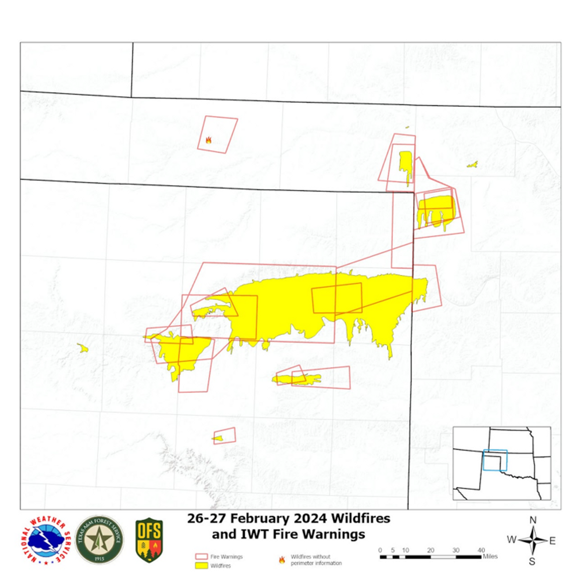
Thousands across the Texas Panhandle received wireless emergency alerts Feb. 26 and 27, warning of an eminent, dangerous wildfire on the landscape with the potential to expand. These notifications utilized a first-of-its-kind process, benefiting from major advancements in fire and weather prediction technology and a foundation in strong inter-agency relationships.
The Feb. 26 and 27 announcements, requested by local emergency management officials and Texas A&M Forest service and issued by the NOAA National Weather Service, are among the first multi-notification processes that have been used for a large-scale wildfire in Texas.
Built on the expertise of fire behavior and prediction knowledge, the Integrated Team Fire Warning Paradigm Process was initially demonstrated in Oklahoma in 2022 and 2023, in response to the devastating 2018 Camp Fire in California. The new process serves as an improved coordinated method for wildfire detection, notification and action. The process was designed by members of the Southern Great Plains Wildfire Outbreak Working Group, including Texas A&M Forest Service, Oklahoma Forestry Services, National Weather Service and Kansas Forest Service personnel.
“This has been a long-standing work in progress,” said Todd Lindley, National Weather Service Science and Operations Officer. “Brad Smith [Texas A&M Forest Service] and Drew Daily [Oklahoma Forestry Services] worked with us to work through retrospective simulations of fire disasters in the Southern Plains, using the combined knowledge of environmental conditions and technology from the satellites, to depict fire behavior that is particularly dangerous.”
In the creation of this new process, Texas A&M Forest Service brought forth a new perspective for the other agencies in combining fire prediction and weather with knowledge of fire history and behavior. Brad Smith served as a catalyst in the expansion of prediction resources and technology for the state, implementing more than 150 new weather stations statewide that are used for fire potential monitoring.
The satellite hotspot detection process of the multi-agency warning system is initiated when a red flag fire day is in effect. A red flag warning is issued by the National Weather Service when the combination of weather conditions and composite fuel moisture support extreme fire danger. On these days, the National Weather Service and emergency management services within the warned area will repeatedly assess fire conditions.
Texas A&M Forest Service Predictive Services utilizes additional tools to monitor fire potential by measuring the fire environment including fuel and weather. These factors, paired with an extensive knowledge of fire behavior history in the area, can be used by Texas A&M Forest Service to inform the National Weather Service or local communities on emergency management decisions.
The National Weather Service is able to monitor conditions on red flag days using infrared channels of the new GOES-16 and GOES-17 satellites. “We use these channels of the satellites to detect heat,” said Doug Weber, National Weather Service Senior Forecaster and Fire Program Coordinator. “When a fire hits, it heats up really quick. We’re able to see the flicker on the satellite immediately, and it jumps out on the map.”
Following the initial detection and assessment of a fire through satellite imagery, National Weather Service members notify local emergency management teams and state fire and forestry officials of the fire. More than 350 Texas Panhandle officials and emergency management personnel are currently subscribed to the initial alert system and receive wildfire threat notifications.
Once notified, local officials have the opportunity to assess the threat of the fire to determine whether a wildfire notification for community members is appropriate. Factors such as fire location, fuels the fire is burning and weather are used by state and local officials to determine the fire’s rate of spread and potential impact, which will help determine if a fire warning notification is appropriate.
Within minutes, local officials can request a wildfire or evacuation notification from the National Weather Service to community members within a specified perimeter, similar to other natural disaster alerts issued by the National Weather Service.
Throughout the notification process, the interest of local emergency management teams is paramount to the issuing of the notifications by the National Weather Service. The improved notification process emboldens local emergency management teams to make critical decisions that will affect community members, with the help and support of state officials and neighboring communities.
“It’s highly encouraged that local emergency management officials initiate the fire warning,” said Luke Kanclerz, Texas A&M Forest Service Predictive Services Department Head. “A majority of the fire warnings issued February 26 and 27, were issued by the local and county emergency management officials in the Panhandle.”
Lindley noted that the development of new technology and strong inter-agency relationships have aided in the timeliness of the new notification process.
“This entire process has been accomplished in nine minutes on average, ranging from three minutes to 15 minutes,” said Lindley. “What is significant about that is that previously, we were only authorized to send notifications to the public at the request of local emergency managers, which took 80 minutes in some cases. We have cut that process down significantly so that we can be more forward leaning and proactive on getting these alerts to the public.”
Kanclerz expressed his hopes that this new warning process will provide timelier notification of wildfires, more accurate fire behavior imaging and a safer environment for community members and first responders.
.jpg)

